


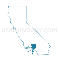
Voting District 56141, Los Angeles County, California
About
Outline

Summary
| Unique Area Identifier | 533585 |
| Name | Voting District 56141 |
| County | Los Angeles County |
| State | California |
| Area (square miles) | 106.55 |
| Land Area (square miles) | 106.34 |
| Water Area (square miles) | 0.21 |
| % of Land Area | 99.80 |
| % of Water Area | 0.20 |
| Latitude of the Internal Point | 34.48820580 |
| Longtitude of the Internal Point | -117.75661020 |
Maps


Graphs
Select a template below for downloading or customizing gragh for Voting District 56141, Los Angeles County, California


Neighbors
Neighoring Voting District (by Name) Neighboring Voting District on the Map
- Voting District 10145, San Bernardino County, CA
- Voting District 10185, San Bernardino County, CA
- Voting District 10190, San Bernardino County, CA
- Voting District 10200, San Bernardino County, CA
- Voting District 10660, San Bernardino County, CA
- Voting District 54602, Los Angeles County, CA
- Voting District 54863, Los Angeles County, CA
- Voting District 54866, Los Angeles County, CA
- Voting District 56144, Los Angeles County, CA
- Voting District 56159, Los Angeles County, CA
- Voting District 56468, Los Angeles County, CA
- Voting District 56471, Los Angeles County, CA
- Voting District 56483, Los Angeles County, CA
Top 10 Neighboring County Subdivision (by Population) Neighboring County Subdivision on the Map
- Victorville-Hesperia CCD, San Bernardino County, CA (370,441)
- South Antelope Valley CCD, Los Angeles County, CA (208,925)
- North Antelope Valley CCD, Los Angeles County, CA (190,690)
Top 10 Neighboring Place (by Population) Neighboring Place on the Map
Top 10 Neighboring Elementary School District (by Population) Neighboring Elementary School District on the Map
- Adelanto Elementary School District, CA (56,751)
- Keppel Union Elementary School District, CA (20,900)
- Wilsona Elementary School District, CA (10,156)
Top 10 Neighboring Secondary School District (by Population) Neighboring Secondary School District on the Map
- Antelope Valley Union High School District, CA (373,523)
- Victor Valley Union High School District, CA (158,707)
Top 10 Neighboring Unified School District (by Population) Neighboring Unified School District on the Map
Top 10 Neighboring State Legislative District Lower Chamber (by Population) Neighboring State Legislative District Lower Chamber on the Map
Top 10 Neighboring State Legislative District Upper Chamber (by Population) Neighboring State Legislative District Upper Chamber on the Map
Top 10 Neighboring 111th Congressional District (by Population) Neighboring 111th Congressional District on the Map
Top 10 Neighboring Census Tract (by Population) Neighboring Census Tract on the Map
- Census Tract 91.17, San Bernardino County, CA (8,267)
- Census Tract 91.07, San Bernardino County, CA (7,272)
- Census Tract 9100.02, Los Angeles County, CA (7,217)
- Census Tract 9001.04, Los Angeles County, CA (6,242)
- Census Tract 9110.01, Los Angeles County, CA (4,201)
- Census Tract 9001.02, Los Angeles County, CA (1,029)
- Census Tract 9303.01, Los Angeles County, CA (886)
Top 10 Neighboring 5-Digit ZIP Code Tabulation Area (by Population) Neighboring 5-Digit ZIP Code Tabulation Area on the Map
- 92301, CA (32,725)
- 92371, CA (16,763)
- 93591, CA (7,285)
- 92372, CA (6,220)
- 93553, CA (2,138)
- 93544, CA (1,259)
- 93563, CA (388)